For the measurement/estimation of which of the following are satellite images/remote sensing data used? 1. Chlorophyll content in the vegetation of a specific location 2. Greenhouse gas emissions from rice paddies of a specific location 3. Land surface temperatures of a specific location Select the correct answer using the code given below.
- A1 only
- B2 and 3 only
- C3 only
- D1, 2 and 3Correct
Explanation
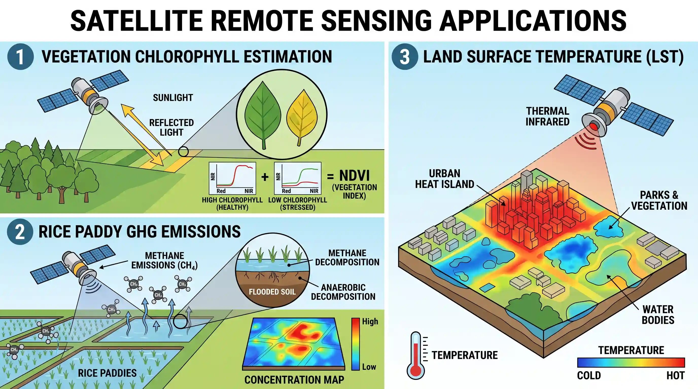
Satellite images and remote sensing data are extensively used for various environmental and geographical monitoring purposes due to their ability to collect data from a distance across large areas. Let's examine each application:
-
Chlorophyll content in the vegetation of a specific location: Correct. Satellite sensors measure the spectral reflectance of vegetation. Healthy vegetation with high chlorophyll content absorbs more red light and reflects more near-infrared light. Indices like the Normalized Difference Vegetation Index (NDVI) derived from satellite data are widely used to estimate chlorophyll content, vegetation health, and productivity.
-
Greenhouse gas emissions from rice paddies of a specific location: Correct. While direct measurement of all types of emissions can be complex, remote sensing can be used to identify and map the extent of rice paddies. Moreover, advanced satellite instruments are increasingly capable of directly measuring atmospheric concentrations of greenhouse gases like methane (a major emission from rice paddies) and CO2, allowing for estimations and monitoring of emission sources.
-
Land surface temperatures of a specific location: Correct. Thermal infrared sensors on satellites detect the heat radiated from the Earth's surface. This data is used to derive Land Surface Temperature (LST), which is crucial for climate studies, urban heat island effect monitoring, agricultural applications, and understanding energy balance.
Given the broad capabilities of remote sensing, all three applications are feasible and routinely carried out using satellite data.
Related questions
More UPSC Prelims practice from the same subject and topic.
- Prelims 2019GS1geography
Which one of the following National Parks lies completely in the temperate alpine zone?
- Prelims 2019GS1geography
Consider the following statements: 1. Asiatic lion is naturally found in India only. 2. Double-humped camel is naturally found in India only. 3. One-horned rhinoceros is naturally found in India only.…
- Prelims 2019GS1geography
Which of the following are in Agasthyamala Biosphere Reserve?
- Prelims 2019GS1geography
Consider the following statements: 1. Some species of turtles are herbivores. 2. Some species of fish are herbivores. 3. Some species of marine mammals are herbivores. 4. Some species of snakes are vi…
- Prelims 2019GS1geography
Consider the following pairs: Wildlife Naturally found in 1. Blue-finned Mahseer : Cauvery River 2. Irrawaddy Dolphin : Chambal River 3. Rusty-spotted Cat : Eastern Ghats Which of the pairs given abov…
- Prelims 2019GS1geography
Why is there a great concern about the 'microbeads' that are released into environment?