The most important fishing grounds of the world are found in the regions where

- Awarm and cold atmospheric currents meet
- Brivers drain out large amounts of freshwater into the sea
- Cwarm and cold oceanic currents meetCorrect
- Dcontinental shelf is undulating
Explanation
The correct answer is C) warm and cold oceanic currents meet.
Here's a detailed explanation:
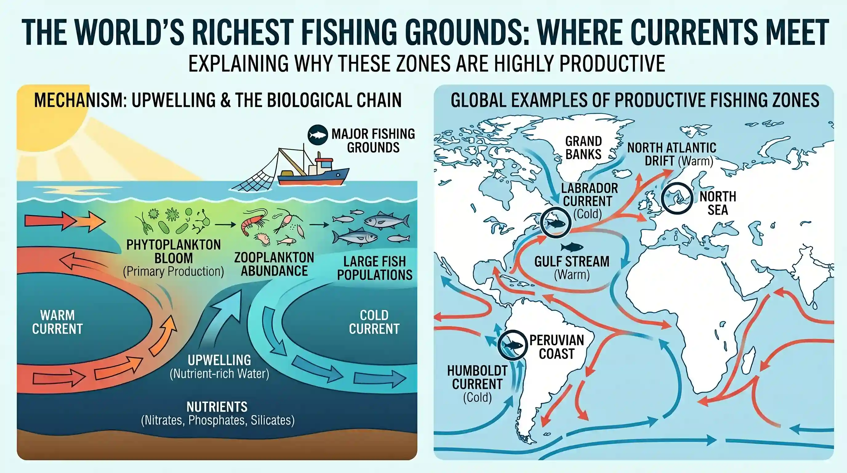
Upwelling: The meeting of warm and cold currents creates zones of upwelling. Upwelling brings nutrient-rich water from the bottom of the ocean to the surface.
Phytoplankton Bloom: These nutrients fuel the growth of phytoplankton, the base of the marine food chain.
Abundant Fish Populations: Phytoplankton supports zooplankton, which in turn supports fish populations, making these areas highly productive fishing grounds.
Examples: The Grand Banks of Newfoundland (meeting of Gulf Stream and Labrador Current), the North Sea (North Atlantic Drift and colder currents), and the coasts of Peru and Chile (Humboldt Current) are prime examples.
Why other options are incorrect:
A) warm and cold atmospheric currents meet: While atmospheric currents influence weather patterns, they don't directly create the nutrient-rich conditions necessary for abundant fish populations.
B) rivers drain out large amounts of freshwater into the sea: River mouths can be locally productive, but the effect is limited compared to the large-scale upwelling caused by ocean currents. Excessive freshwater can also be detrimental to marine life.
D) continental shelf is undulating: Undulating continental shelves can create varied habitats, but this is not the primary factor determining the most important fishing grounds globally.
Related questions
More UPSC Prelims practice from the same subject and topic.
- Prelims 2013GS1geography
Which one of the following pairs is correctly matched?
- Prelims 2013GS1geography
Which of the following can be found as pollutants in the drinking water in some parts of India? 1. Arsenic 2. Sorbitol 3. Fluoride 4. Formaldehyde 5. Uranium Select the correct answer using the codes …
- Prelims 2013GS1geography
The Narmada river flows to the west, while most other large peninsular rivers flow to the east. Why? 1. It occupies a linear rift valley. 2. It flows between the Vindhyas and the Satpuras. 3. The land…
- Prelims 2013GS1geography
On the planet earth, most of the freshwater exists as ice caps and glaciers. Out of the remaining freshwater, the largest proportion (a) is found in atmosphere as moisture and clouds (b) is found in f…
- Prelims 2013GS1geography
Consider the following pairs : 1. Nokrek Bio-sphere Reserve: Garo Hills 2. Logtak (Loktak) Lake : Barail Range 3. Namdapha National Park: Dafla Hills Which of the above pairs is/are correctly matched?
- Prelims 2013GS1geography
Consider the following : 1. Electromagnetic radiation 2. Geothermal energy 3. Gravitational force 4. Plate movements 5. Rotation of the earth 6. Revolution of the earth Which of the above are responsi…