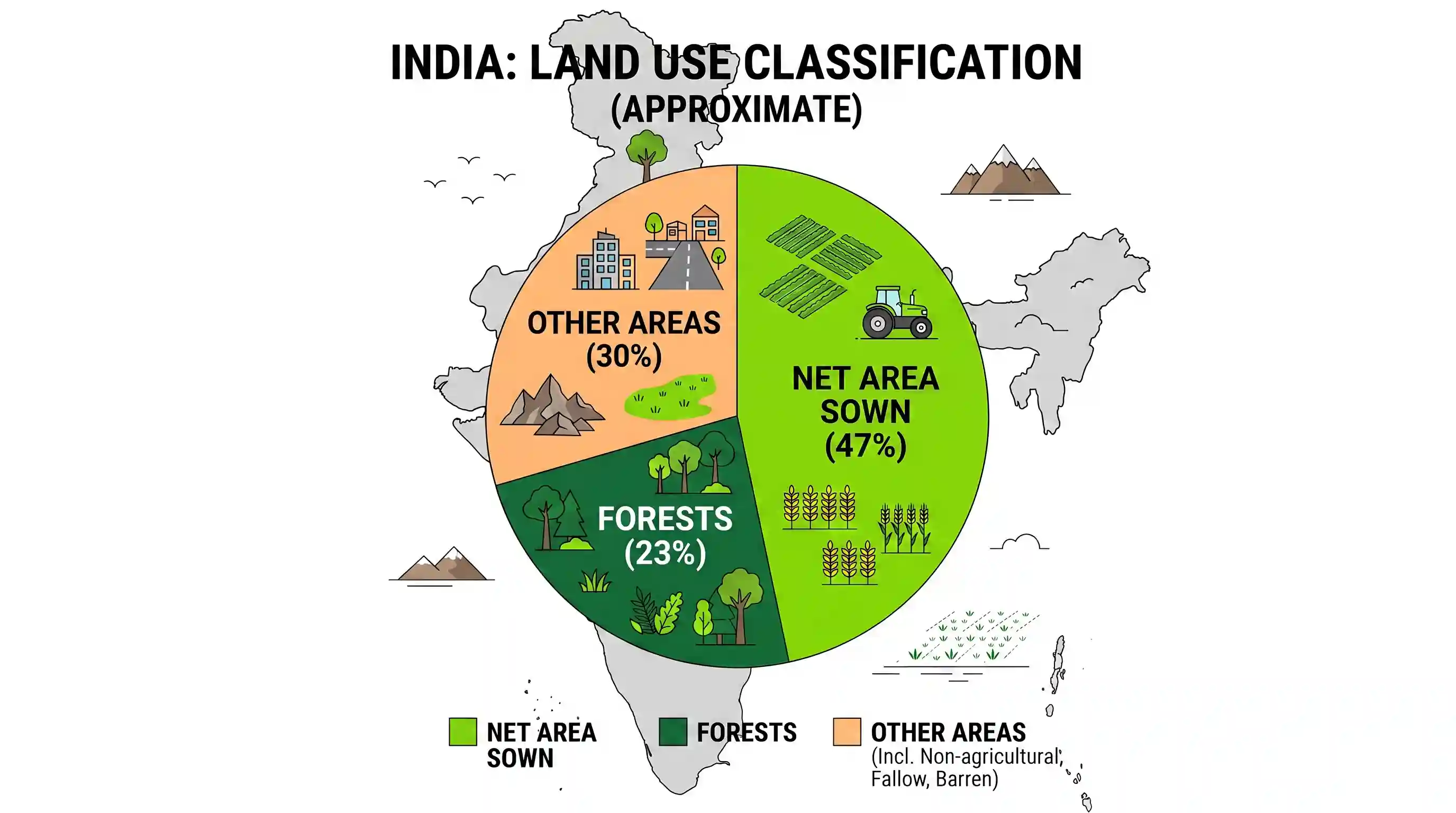
The approximate representation of land use classification in India is
- ANet area sown 25%; forests 33%; other areas 42%
- BNet area sown 58%; forests 17%; other areas 25%
- CNet area sown 43%; forests 29%; other areas 28%
- DNet area sown 47%; forests 23%; other areas 30%Correct
Explanation
The correct answer is D because it most accurately reflects the approximate land use classification in India.
Analysis of options: A) Net area sown 25%; forests 33%; other areas 42% - The net area sown is too low, and forest cover is too high (33% is the target for sustainable development, not the current reality). B) Net area sown 58%; forests 17%; other areas 25% - The net area sown is too high, and forest cover is too low. C) Net area sown 43%; forests 29%; other areas 28% - While closer, the forest percentage is still a bit high compared to actual figures, and net area sown slightly low. D) Net area sown 47%; forests 23%; other areas 30% - This option closely matches the official land use statistics for India, where net area sown is typically around 45-48%, forest cover is around 21-24%, and the remaining constitutes other land uses. Therefore, D is the best approximate representation.
Related questions
More UPSC Prelims practice from the same subject and topic.
- Prelims 2010GS1geography
Though coffee and tea both are cultivated on hill slopes, there is some difference between them regarding their cultivation. In this context, consider the following statements: 1. Coffee plant require…
- Prelims 2010GS1geography
Following are the characteristics of an area in India: 1. Hot and humid climate 2. Annual rainfall 200 cm 3. Hill slopes up to an altitude of 1100 metres 4. Annual range of temperature 15°C to 30°C Wh…
- Prelims 2010GS1geography
With reference to the mineral resources of India, consider the following pairs: Mineral 90% Natural sources in 1. Copper ... Jharkhand 2. Nickel ... Orissa 3. Tungsten ... Kerala Which of the pairs gi…
- Prelims 2010GS1geography
In India, which type of forest among the following occupies the largest area?
- Prelims 2010GS1geography
Tamil Nadu is a leading producer of mill-made cotton yarn in the country. What could be the reason? 1. Black cotton soil is the predominant type of soil in the State. 2. Rich pool of skilled labour is…
- Prelims 2010GS1geography
Rivers that pass through Himachal Pradesh are